Tracking Ammonia Pollution
Quantifying the atmospheric NH3 emissions from local sources from infrared satellite observations
The effect of Ammonia emissions
According to the World Health Organization (2018), ambient air pollution accounts for an estimated 4.2 million deaths per year. Ammonia (NH3), which represents 50% of nitrogen emissions, plays a key role in the formation of atmospheric particles (PM-Particule Matter). Beyond air quality, NH3 indirectly contributes to our changing climate - as PM affects the Earth's radiative budget - and has serious consequences on biodiversity following its transport and deposition.
In Europe, above 60 % of all ecosystems are thought to be exposed to nitrogen deposition exceeding critical loads*
Sources of NH3 emissions and their consequences
Pr Coheur and his team, from Université Libre de Bruxelles, have for principal objective to provide a comprehensive and rigorous view - qualitative and quantitative - of the contribution of local sources, from industries and agriculture, to the total emissions of NH3 worldwide. The project also aims at assessing the impact of these local sources on our environment and health, locally and beyond (transboundary transport of air pollution).
15 years of global NH₃ measurements exploited
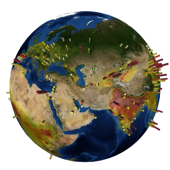
Above 500 industrial / agricultural point sources monitored
The work: analyzing satellite measurements
The study will extend the improved understanding of NH3 distribution to more local sources along with distribution profile with time and distance.
To do so, Pr Coheur’s team will :
- quantify and benchmark emissions of NH3 agricultural and industrial sources using satellite measurements.
- characterize the daily, weekly and seasonal cycle of NH3 and trace these back to varying industrial emissions, farming practices and environmental conditions.
- implement these spatial and temporal features into state-of-the-art models to better assess the impact of NH3 emissions on air quality and the environment.
- determine the long-term time evolution of atmospheric NH3, its response to policy regulations, future emission scenarios and our changing climate.
Interactive map of ammonia point sources that is maintained by ULB
Focus : Tracking Ammonia using infrared (IR) satellite sounders
Air pollution involves a succession of reactive trace gases and airborne particles, which can partly be monitored with instruments localized at the surface of the earth. However, even when they are organized in networks, these local measurements fail to capture the complexity and variability of the atmospheric composition.
In recent years, instruments on Earth Observation (EO) satellites have revolutionized our view of the global atmospheric system and of its anthropogenic imprint. This is noteworthy the case for nitrogen dioxide (NO2) and ammonia (NH3), the two most important reactive nitrogen compounds emitted in the atmosphere. The project Tracking Ammonia Pollution from IR satellite sounders (TAPIR) intends to further our knowledge of local emissions of NH3, by:
- exposing fainter emitters,
- characterizing their short-term variability and long-term trends,
- improving the quantification of their emissions and
- assessing their impact on human health and the environment on various scales.
This will involve a series of activities, including the development of ultra-sensitive detection methods and of sophisticated imaging techniques for the satellite data, the use of model simulations on the local scale; and possibly of demonstration measurements from aircrafts.
The team of Pr Coheur at ULB SQUARES* is going to use infrared satellite sounders since they offer unprecedented observational means to map atmospheric NH3, down to the scale of individual emitters. TAPIR will principally rely on 15 years’ worth of global and daily NH3 measurements from the IASI satellite sounder, onboard the European Metop platforms, possibly complemented by recent measurements from geostationary sounders. The research team of Pr Coheur processes 5 million pieces of IASI data per day. In the additional objective to validate the satellite-derived emission fluxes, dedicated field measurements, from the ground or aircraft, will possibly be performed during the project.
IASI instrument - Infrared Atmospheric Sounding Interferometer - was developed by the French National Center for Space Studies (CNES) in cooperation with Eumetsat, the European Organization for the Exploitation of Meteorological Satellites. The IASI instrument is designed for operational meteorology and monitoring of atmospheric chemistry and climate.
* Spectroscopy Quantum Chemistry Atmospheric Remote Sensing
What the Air Liquide Foundation is doing
The Air Liquide Foundation is financing the salary of a researcher half-time for three years. The Foundation is also participating in operation costs, especially for the field measurement campaigns.


